On 10July we leave Fakarava setting sail for The Society Islands. We have a beautiful 2 day sail to Marina Taina anchorage, Pape'ete, Tahiti. We would spend 30 fantastic days amongst friends on land and sea. We are so lucky and blessed to have the ability to have the freedom to travel, explore and be one with our adventure across the globe making new and seeing old friends along the path.
The archipelago is believed to have been named by Captain James Cook during his first voyage in 1769, supposedly in honour of the Royal Society, the sponsor of the first British scientific survey of the islands; however, Cook stated in his journal that he called the islands Society "as they lay contiguous to one another. Tahiti is the heart and soul of the South Pacific, Tahiti is the largest in a chain of islands that make up French Polynesia. The name can either refer to the main island or the entire destination. Commonly referred to as The Islands of Tahiti, French Polynesia is a collection of 118 islands and atolls scattered across an impressive nautical surface area the size of Western Europe. Still, these tiny islands—many of which remain uninhabited—make up a total landmass of only 1,600 square miles (4,100 sq. km).
Culturally the Polynesians continue to celebrate their roots by having ancestral rafts come from Hawaii, Rapa Nui and New Zealand making up the 'triangle' with Tahiti in the center of Polynesian culture. Taken from tahiti.com: Ancient History - 4000 BC - 1000 AD
The great migration from Southeast Asia began around 4000 BC, in which daring seafarers sailed the open ocean in their large double-hulled canoes—using only the sun, stars, wind, ocean currents, and flight patterns of the birds—to navigate to new islands.
Researchers conclude that Tonga and Samoa were settled as early as 1300 BC. From there, another migratory wave brought these new explorers even farther eastward, reaching the Marquesas around 500 BC.
Over the next several centuries, the voyages continued north to the Hawaiian Islands, east to Easter Island (Rapa Nui), and south to the Tuamotu Archipelago and the remaining Tahitian Islands. Raiatea, known historically as Hawaiki, eventually became the religious and cultural center. From there, around 1000 AD, the canoes proceeded to the Cook Islands and New Zealand, completing the Polynesian Triangle.
 |
| The Society Islands of French Polynesia |
French Polynesia, with its capital at Papeete on the island of Tahiti, is comprised of five archipelagos, including the Society Islands (where Tahiti is located), the Austral Islands, the Tuamotu atolls, the Gambier Islands, and the Marquesas.
All of the groups are mostly volcanic high-rise islands, except the Tuamotu chain, which is comprised of low-lying coral atolls.
 |
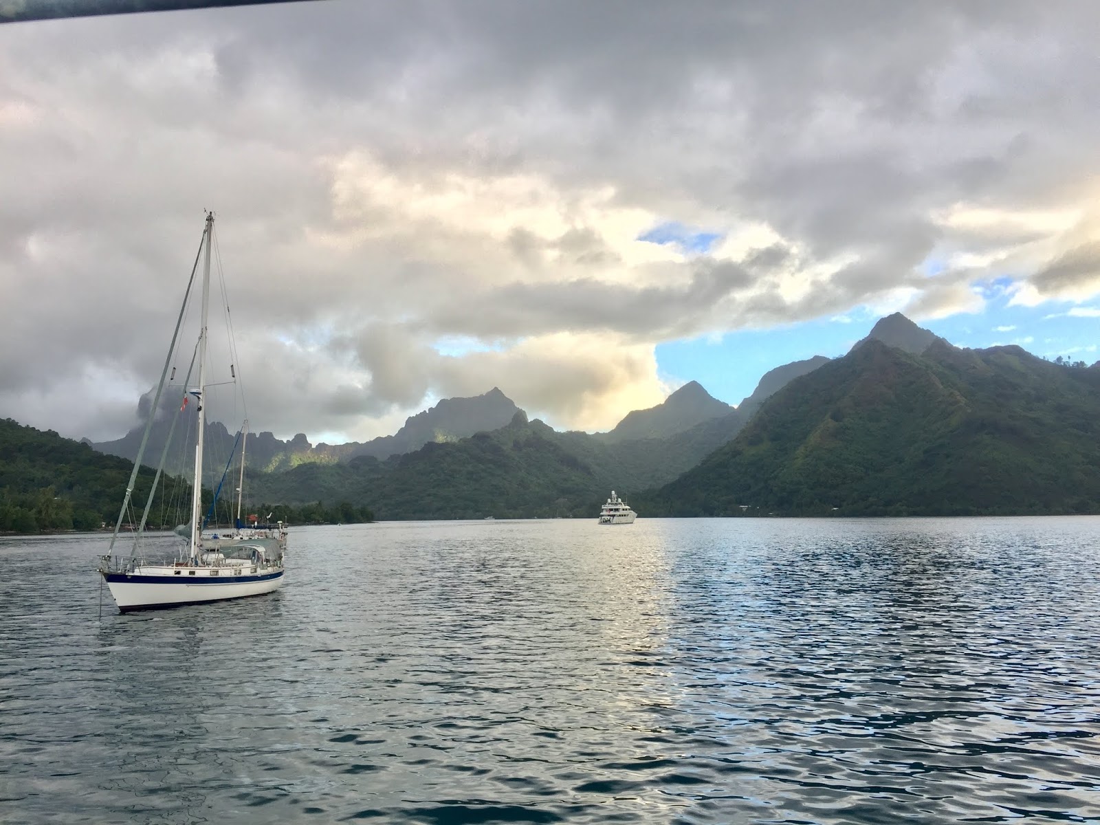
Sunrise in Taina anchorage with Mo'orea in the background
|
We were excited to be in Tahiti for Bastille Day, but it really was not celebrated here by the local people since it is more a French Holiday. We got up early to go to the Marchee in Pape'ete. Martin spoke the most French and was able to get us all rides as the buses were not running on this day, plus it was a Sunday.
Marché Pape'ete or Pape'ete Market is an extensive market place, in the capital of Tahiti. The market sells fruit, vegetables, fish, oils, handicrafts and various souvenir items. Vendors also sell local textiles and handcrafted items such as shell necklaces. The entire market was not open but the energy and kindness of the people was seen by us all. We enjoyed walking around the market and purchasing goods on the street to taste, explore and savor. The colors are just beautiful with textiles, fruits, shells and pearls.
 |
| Marcheè Pape'ete |
 |
| Fresh produce, fresh meat, baked goods, textiles and smiling faces. |
 |
| Chopping pork for sale, we tried it. This was delicious. |
After the market Keith, Kathy, Dan and I walked back slowly the 8km back. We leisurely stopped in a bulk store and a market for something cold to drink. We saw the local culture and where people lived in close proximity to the water. Some on the edge of the road with a severe drop off.
We found a stand at the round about by the InterContinental selling lychees, banana and pineapple. Relatively inexpensive. We sat under a tree eating the lychee and chatting. Perfect day catching up with them, relaxing on the side of the road in Tahiti.
Keith and I had several fantastic experiences with Marama Tours, first a half day Safari trip into the crater, second was a full day tour through the crater and to the other side of Tahiti Nui then thirdly the Circle Tour of Tahiti Nui. The tours are well run, amazing fun on the Safari on rough roads through the crater with incredible vistas, waterfalls and rich with Polynesian cultural centers for worship.
The Half Day Safari 4x4 tour with Marama Safari:
 |
Tahiti's Maroto Valley known as the Papenoo Valley, is a magical place once inhabited by ancient Polynesians.
|
 |
| Wild cock by the river before we crossed over the water |
 |
| Topatari Falls (or the Topatari Waterfall), which was the first major waterfall we saw as we went from north to south in Papenoo Valley |
 |
| Keith and Wayne at Topatari Falls |
 |
| Temple Maore, it's interesting to see the stone infrastructure, as well see the abundance of fruits that litter the grounds -- noni, coconuts, guava, macadamia nuts and more. The people still bring gifts to the gods in the form of natural items found on the island, flowers, palm branches, and leaves. |
 |
| Wayne at the last stop of the half day where we enjoyed a swim on Papenoo River |
 |
| The day was cool and full of energy, we enjoyed the Safari tour, culture and swimming. Papenoo Valley. |
 |
| Wayne and Keith at the end of the tour, we turn to go back out of the Papenoo Valley and back to Pape'ete |
The full day Marama Safari 4x4 trip took us to Topatari Falls first stop, east coast of the island. Puraha Falls was the second stop into the Valley. Rocky told us the meaning of the Tulip of Gabon, orange flowers on trees, when all the tree is in bloom it announces the Humpback Whale coming to breed. Fara Hape represents all Polynesia (celebrated by Rapa Nui, Hawaii and NZ).
 |
| Wayne at Puraha Falls |
 |
| The Papenoo River is the largest on Tahiti. When Christianity began to spread along the coastal regions, the Papenoo Valley became a last refuge for those faithful to the ancient Polynesian religion, and until 1846 it was also a shelter for the Tahitian rebel forces that opposed the French takeover. |
 |
| Maroto Valley, view from Hotel Relais de la Maroto |
 |
| View from Relais de la Maroto |
 |
Built in the 14th century, Fare Hape used to be a place where religious practices and spiritual ceremonies took place. Polynesians from all over the world — Hawai, New Zealand, Rapa Nui — travel here once a year by ancestral double canoe raft to share cultures.Tahiti is in the center of Polynesia as New Zealand, Hawaii and Rapa Nui form the triangle.
Due to its location in the center of a volcanic crater, the site was also believed to hold special religious power. There is an exhibit of the constellations and the alignment with the mountain peaks that surround the valley. |
 |
| Marae Fare Hape |
 |
| Marae Fare Hape |
 |
| Maroto Valley with view of Mount Orohena 2.241m (7,352 feet), Tahiti Nui's highest peak. The peak is surround by clouds on this day. |
 |
| Fare Hape Village |

The mountains align with the constellations depicted on the photos to the left.
 |
| During our visit to Fara Hape Village we went for a swim and enjoyed the waterfall |
 |
| Keith takes a swim then enjoys the waterfall's refreshing water |
 |
| View of the Papenoo Valley before we go through the tunnel to the west side of the island. We were high as we could go on this road, were at the head of Papenoo Valley. There were a few more waterfalls around but most of them looked ephemeral or had power lines in the way. |
 |
| Tunnel that goes through the island |
 |
| When we got out of the tunnel, we were now looking towards the south end of Tahiti Nui. Down below, we could see a hint of a lake, which was called Lake Vaihiria. It is the largest lake in Tahiti. |
 |
| Pretty waterfall Vaihiria Valley |
 |
| Waterfall at Déversoir du Lac Bleu (Lake Bue Spillway |
 |
| Rivière Vaihiria (Vaihiria River) |
 |
| Keith sitting in the 4x4 while we stopped to wash the truck on Rivière Vaihiria (Vaihiria River) |
 |
| Rivière Vaihiria (Vaihiria River) |
We were incredibly lucky to have spent time with our community of friends while in Tahiti. Our friends, Dan and Kathy on Lungta were at anchor in Taina Anchorage when we arrived. They were on deck waving to us when we sailed past with Damian and Camilla, from Rapa Nui on board. We met Damian and Camilla on three different occasions in Rapa Nui, kindred spirits.
While Martin and Patty took a couple of weeks for a romantic cruise we moved over to Lungta and slept in the nest. We played games of chess, cooked, great moments and conversations, music was a huge theme on board with Damian and Camilla playing on the trunk while we listened and sang along. Blissful evenings of being serenaded to sleep.
A group of us (Martin, Patty and Sheena from sv Otra Vida, Dan, Kathy, Keith, Damian, Camilla and I from sv Lungta, James, Kimmie and Leo from sv Zingaro and Josh, Rachel and Nichola from sv Agappe) joined together to dive a plane wreck in 20 meters of water. Across the channel was a wooden boat wreck that Damian and I were able to free dive.
 |
| Keith, Wayne, Patty, Berita, Martin, Daniel (sitting background) James on svZingaro |
 |
| Patty, Keith, Camilla and Damian sailing on svZingaro to dive the wreck |
 |
| Plane wreck at 20 meters depth, Wayne was free diving the wreck and Keith used scuba gear (photo taken free diving) |
 |
| Kim from svZingaro free diving the wreck (Keith took photo) |
 |
| Damian diving the wreck with Keith |
 |
| Plane wreck |
 |
| Josh (svAgappe) free diving |
 |
| Close-up of the wreck |
 |
| Keith and Josh |
 |
| Kim and James sitting on the wing |
 |
| Damian and Camilla, two lovely souls we met in Rapa Nui then on Lungta |
 |
| Sunrise over Tahiana |
 |
| Sunrise view of Mo'orea |
 |
| Good morning Tahiti at 5:40 am |
We stayed on svLungta with Dan, Kathy, Damian and Camilla for a few weeks. During that time we sailed over to Mo'orea. We had the opportunity to snorkel, hike to Belvedere then down past ancient archeological ruins, swimming with the sting rays and black tipped reef sharks.
On 31Jul, After breakfast, Dan and Kathy took us by dinghy to the end of the bay to the beach near the road to Belvedere. We started walking then got a ride from a French couple to Belvedere. We took some photos of the view then looked at the map for the path down.
We decided to take the red route to the ruins then took the path behind the ruins to see more of the Ahu and Mareau. Most built in the 17th century. Really well preserved and recent archeological data secured.
We walked down to the adventure came but it would take 4 hours, we continued our walk to the Pineapple path leading us through the crater and fields of pineapple and forests with bananas, flora and fauna.
We came out by where we had hiked earlier in the day. Took some photos of the cows and mountains then got a lift from a guy in an electric car to the beach on Oponohu anchorage.
 |
| Sailing from Taina anchorage, through the pass towards Mo'orea. surfers in breakwater |
 |
| Destination Mo'orea |
 |
| The helm inside the pilot house on svLungta |
 |
| svLungta under sail from Tahiti to Mo'orea |
 |
| We are off to Mo'orea with Tahiti in the background |
 |
| Oponohu anchorage Mo'orea |
 |
| View of the bay with the cloud moving away exposing the highest point |
 |
| Damian, Camilla, Wayne and Keith on svLungta |
 |
| Sunset reflects over Oponoho Anchorage |
 |
| Sunset to the West over the Pacific from Oponoho Bay |
 |
| Sunsetting behind us in Oponoho Bay reflection from West to East |
 |
| Leopard sting ray |
 |
| Our view from the water looking over the bay |
 |
| Oponoho Bay, Mo'orea |
 |
| Belvédère viewpoint Cook's Bay |
 |
| Belvédère viewpoint Oponoho Bay |
 |
| Keith at Belvédère viewpoint Oponoho Bay |
 |
| Wayne at Belvédère viewpoint Cook's Bay |
 |
| Keith hiking on Red Trail from Belvédère viewpoint |
 |
| Marae Faré-Aito (house of warriors) |
 |
| Tahua Te'a (archery platform) |
 |
| Diagram of the archaeological site |
 |
| The marae, a canoe |
 |
| Rōtu'i (899m) coming out of the caldera in Opunohu Valley |
 |
| Ahu-ō-Māhine(Māhine's altar) |
The marae was built on ancient remains, dates back to the 17th century. The mare with 3 step ahh, oriented towards Mou's Roa. A great part of the structure is made of worked round stones or naturally round stones. Constructed in the fashion for worship to 'Pro, god of fertility and war.
 |
| closer view of the construction |
We crossed a water source during our walk through archaeological ruins.
 |
| Beautiful lush path leading to another archaeological site |
 |
| Known as ScMo-106 Complex |
Complex consists of 2 temples, several paved shrines with stone uprights, elaborate pavements ad a council platform. The complex represents one of the five main ritual political centers include clusters of temples, shrines, sculpted god figures and elite structures such as council meeting platforms and archery platforms.
They were the sites of the most sacred religious ceremonies, including chiefly investiture and initiation rites (circumcisions and puberty rites, marriage and deth ceremonies). important political events took place here, such as war councils and feasts where neighboring communities and their chiefs were honored guests. Economic activities were crucuial elements of ritual-political centers, including the annual first fruit ceremonies where Mā'ohi offered tributes to chiefs. (tribute included pigs and other food items, yellow and red bird feathers used to decorate elite clothing, and rolls of plaited mats and barkcloth) [taken from posting at the site].
 |
| Along the Pineapple trail towards Oponoho Bay. We walked through the crater valley through a pineapple plantation |
 |
| Pineapple more mature and near ready to harvest |
 |
| Vast plantings of pineapple in the crater valley |
 |
| Dirt hiking trail through the crater, pineapple on both sides |
We stopped at the Adventure Camp to find out how much time we needed to go through the camp, rope walks, zip-lines and other activities but we needed 3 hours more. Next time we can do it this for fun.
 |
| At the beginning or end of the hike, we are just a short walk to the beach |
 |
| svLungta at anchor |
 |
| Sting Ray City swimming with sting rays and black tip reef sharks |
 |
| We are headed to Sting Ray City |
 |
| Sting Ray City |
 |
| Sting Ray City with sting ray and assorted fish |
 |
| Sting Rays coming towards Keith |
 |
| Keith swimming with the sting rays |
 |
| Sting Ray City swimming with the Black Tip Reef Sharks and Sting Rays |
 |
| Keith and I swimming with the sting rays |
 |
| Camilla |
 |
| Kathy taking a photo of the Morey Eel and he decided to take a closer look |
 |
| Beautiful day swimming between the two motus off Mo'orea |
 |
| Heading back to the boat against the waves and wind |
 |
| Our last few days in Tahiti were spent at Philippe and Teva's with a view of Mo'orea |
 |
| Sunset over Mo'orea |
 |
| The beauty of French Polynesia |
We met some wonderful people along the way and look forward to long term relationships. We will be back to French Polynesia one day in our own sailboat.
Thanks for all the memories...our hearts go out to you all for making this a spectacular trip.