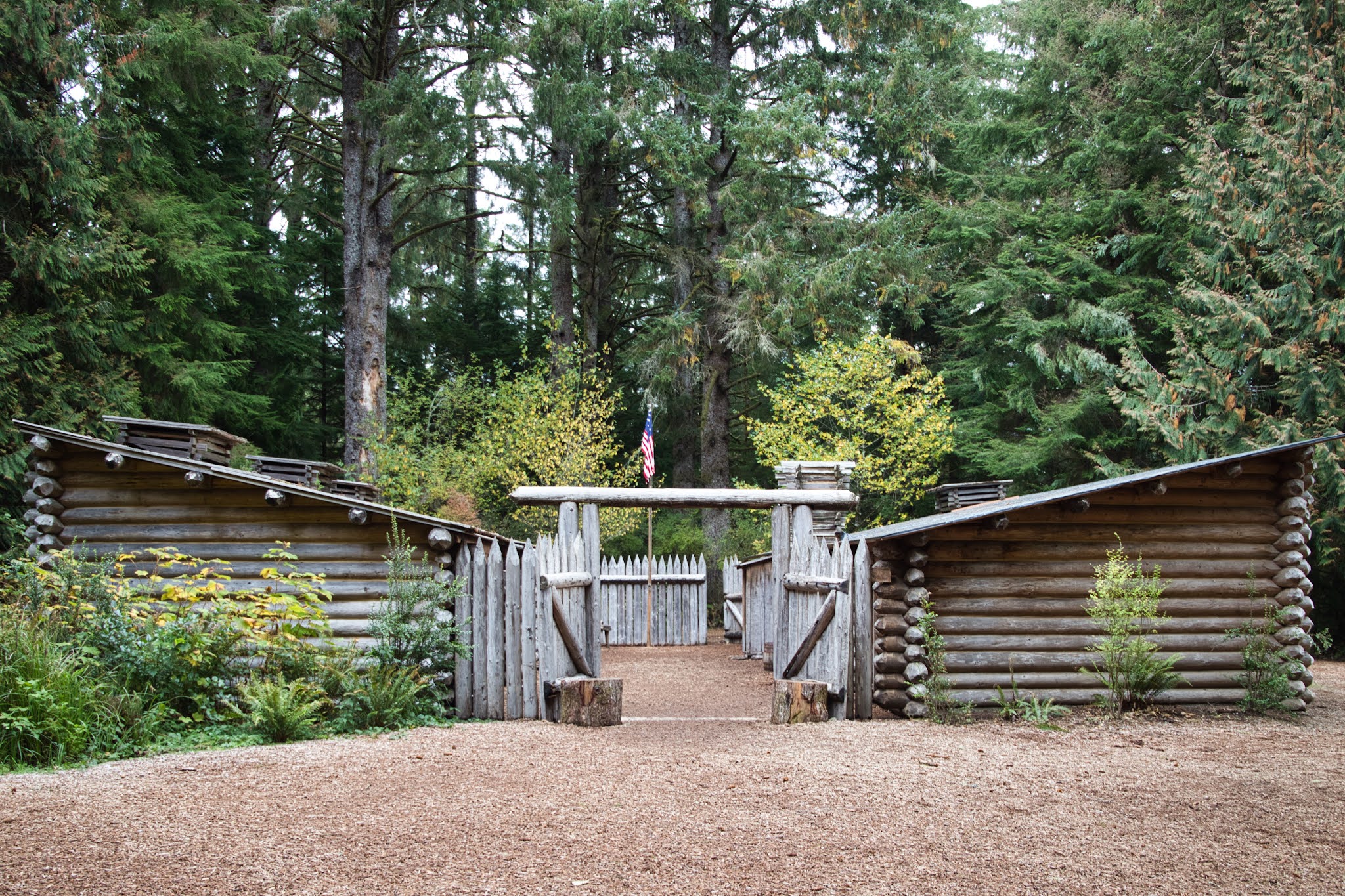
We are so happy to be back on the road after the repairs and headed to Astoria, OR via 26N to 101N. We camped over night at Fort Steven's State Park in Hammond, OR we parked in Site E145. We plugged in, had Chicken Pot Pie for dinner. Beautiful campground with full or partial hook-ups, clean bathrooms and nice warm showers.
The following day we woke to rain, such a beautiful sound on the roof. We will start at Milepost 0 and drive south to Milepost 363 on the California Border. Entering the Lewis and Clark National Historic Park driving on 101 north to Fort Stevens, it runs from Long Beach, WA to Cannon Beach, OR.
Toured Fort Stevens, Peter Iredale shipwreck and battery points within the State Park. It was crazy windy with sand blowing. The shipwreck is from 1906. The waves are crashing in on the beach and wreck. Went to the South Jetty mouth of the Columbia River with major white breaks and waves.
 |
| Peter Iredale Shipwreck - formerly a four-masted steel barque sailing vessel that ran ashore October 25, 1906, on the Oregon coast en route to the Columbia River. She was abandoned on Clatsop Spit near Fort Stevens in Warrenton about four miles south of the Columbia River channel. |
 |
| Rough seas |
 |
| Battery Russell |
Wildlife Viewing Bunker on the Columbia River very windy for any birds. Went to Battery Russell and Battery Commanders Station rain let up allowing us to take some photos. The homeless population has multiplied in Oregon even onto the coastal area. We had a long enough window without ran to visit historic Fort Stevens 1863 Civil War fortress, Japanese Submarine attacked the fort while it was active until 1944.
 |
| Battery Commanders Station |
A must do was the Astoria Column, we walked up 164 steps the column, to view the Young, Lewis and Clark and Columbia Rivers. Beautiful column and vistas. We chatted with a woman at the column then her husband came over, we chatted for a long while as we admired the view.
 |
| Astoria Column |
Dedicated by the Great Northern Railway in 1926, the Astoria Column stands today as a monument to those people. Attilio Pusterla's sgraffito artwork, an ancient technique in which images are engraved into wet plaster and then colored powders are hand-blown into the outlines, is a source of wonder for many. The lower bands begin with Captain Gray’s arrival to the Columbia River in May 1792, and his first contact with the Chinook and Clatsop tribes. As it winds up to the top of the column, the histogram continues with the Lewis and Clark Expedition’s arrival in the area, the arrival of the first European settlers, and ends with the arrival of the railroad to Astoria in 1893.
 |
| Convergance of Young River, Lewis and Clark River join the Columbia River |
 |
| Viewing Untethered (RV) from the top of the Column |
Our second day on the coast, we are in Astoria, we stopped at the Chamber of Commerce Visitor Center spoke with a great woman that gave us tons of information about the area. She recommended Mile by Mile tourist magazine detailing every milepost on the coastline with points of interest and hiking information. This became our go to Bible for the entire trip southerly on 101.
We head over to Fort Clatsop, a unit within Lewis and Clark National Historical Park. Walked the river trail along the Lewis and Clark River and back to the Visitor Center. Met a Ranger on our hike that was very informative and helpful. She told us about mushrooms and National Parks needing volunteers.
 |
| Fort Clatsop |
Fort Clatsop was the winter encampment for the Corps of Discovery from December 1805 to March 1806. The visitor center includes a replica of Fort Clatsop similar to the one built by the explorers.
 |
| Lewis and Clark River Trail |
 |
Autumn is arriving|
| Ecola State Park lone tree |
|
Really nice 2.90 mile hike, between rain storms, along the Lewis and Clark River. Headed to Seaside, we walked the Main Street down to the beach and Lewis and Clark Monument End of Trail. All the stores were closed, coastal town.
From Ecola SP we saw Haystack, Cannon Beach and Tillamock Rock Lighthouse. We had breakfast then started south further on 101 in the Oregon Rocks National Wildlife Refuge.
 |
| The beauty of no one on the road at 8:00 |
 |
Ecola State Park Lone Tree
|
 |
| Tillamook Lighthouse off the coast |
 |
| Cannon Beach |
 |
| Cannon Beach and Haystack in the fog |
 |
Cannon Beach
|
 |
| Haystack |
 |
| Part of the beach continued to get fogged over |
 |
| Within an hour the fog cleared |
 |
| Bicycling on Cannon Beach in B&W |
Came back through Cannon Beach, parked and walked to the beach to photo and see Haystack. We are in for the largest storm on record that has hit the Pacific Northwest. King tide on Sunday.
Heading South from Cannon Beach on 101 to Nehalem.
We stopped at Silver Point Interpretive Overlook, Bald Eagle on top of Silver Point Rock. Rock to the south Jockey Cap. Further south close to the coast is Castle Rock.
 |
| Silver Point Interpretive Overlook |
Stopped at Hug Point State Recreation Area. Walked the cobbles on the beach (12:00 - 12:41). Drove through Arch Cape Tunnel. Stopped for lunch at the highest point on the Oregon Coast, below Neahkahnie Mountain off 101. Gorgeous overlook within Oswald West State Park.
 |
| Hug Point State Recreation Area Beach |
 |
| Hug Point Beach |
 |
| Sun flare Hug Point |
 |
| Oswald West State Park Overlook |
Continues down 101 to Tillamook Creamery. Self guided tour to watch the cheese making, weighing and packaging. Tons of information, while interesting to read and understand their process, seeing the cheese come from the molds to packaging was fascinating. Despite the machinery there is a lot of hands on quality control in the plant.
 |
| Tillamook Creamery |
 |
| Cheese on conveyor belts ready for processing and packaging |
We went to Cape Meares National Wildlife Refuge and Cape Meares lighthouse, we boondocked outside the gates on the dead end.
 |
| Cape Meares Lighthouse sunset |
 |
Rough water in the Pacific along Cape Meares
|
 |
| We continued from Astoria down the coast road to Cape Lookout, 75 miles in 4 days. |
We are into Day 4 driving down the Oregon Coast, taking the Oregon State Byway to Cape Lookout. It was pouring rain, stopping at Cape Lookout State Park. The campsites were flooded, really pretty location on the water with dunes between the site and Pacific. We left the campground continuing onward on Three Capes Route to Cape Kiwanda.
To our surprise we saw giant sand dunes between Cape Lookout and Cape Kiwanda, Sand Lake State Recreation Area covering 1,076 acres with forest and Pacific Ocean surrounding it. It is about 15 miles south of Tilamook, OR.
 |
| Sand Lake State Recreation Area |
 |
| To our surprise, Sand everywhere |
 |
| The Three Capes Route takes you right through the dunes. This is the right side. |
 |
| Three Capes Route coastal road |
 |
| Sitka Sedge State Natural Area |
Sitka Sedge State Natural Area is an estuary and beach on the north coast of the U.S. state of Oregon in Tillamook County. Sitka Sedge consists of 357 acres of tidal marsh, mudflats, dunes, forested wetlands, and uplands at the south end of the Sand Lake estuary, north of Tierra Del Mar.
We got to speak with the Camp Hosts. He and his wife were walking their two Skipper Kees along the path of the 85 year old dike built by a farmer. Sand Lake was to our right and saltwater marsh area. He recommended walking over to the estuary along Sand Lake and the Ocean.
The rain finally stopped long enough for a 2.39 mile hike at Sitka Sedge State Natural Area in Cloverdale, OR off Sandlake Road inside 101 along the coast. We took the Dike Trail to Estuary Trail and the Beach loop. Beautiful natural area with tree canopy over the trails with tons of mushrooms. We had a really nice hike for 1:30 hours before the rain came back.
While it started raining again we continued the journey down the Three Capes Route Loop towards 101, this is a must see along the coast. The Oregon Coast has so much to offer for hikers, nature lovers, birding and beaches.
 |
| Intense winds, high surf and empty spectacular beach |
 |
| Cape Overlook, Cloverdale, OR |
 |
| With all the rain, the mushrooms are abundant on the hiking trails in Sitka Sedge State Natural Area |
 |
| Gleneden Beach State Recreation Area |
The road along the coast collapsed onto the beach. The park along the beach was not harmed. Waves were 6-8' with strong easterly winds. It was an amazing experience to drive and hike along the coast.
 |
| Cape Kiwanda State Natural Area |
 |
| Boiler Bay State Scenic Viewpoint |
 |
| Watching the Pacific churn from Boiler Bay |
 |
| Depoe Bay |
 |
Devil's Punchbowl
|
 |
| Devil's Punchbowl |
 |
| Beach at Devil's Punchbowl, Otter Rock, OR |
 |
| Sunset over Otter Rock State Park Beach |
 |
| Yaquina Head Lighthouse, Newport, OR |
 |
| Yaquina Head Lighthouse Cobble Beach |
We continued the drive down the coastline in howling winds and rain. The sun did come through at times during the day. We did some needed shopping at Columbia then drove further south ending our day having pizza at Cobblestone Pizza in Newport, OR. We drove 75.5 miles and spent the night in Newport. We were treating to an amazing show from nature (haze, mist and sun flares).
We are now 5 days into the journey south from Astoria to Crescent City, CA 215.1 miles to go, the Oregon Coast is a must to travel along Highway 101 and the loops along the coast. In 4 days we have only travelled 148.6 miles. Stopping and taking in the breathtaking vistas, scenery like no other. We crossed the Alsea Bridge in Walport,
 |
| Alsea Bridge crossing from Bayshore to Waldport, OR |
The bridge is 2,910 ft (890 m) in total length, with a 450 ft (140 m) main span that provides 70 ft (21 m). of vertical clearance. The bridge has a latex concrete deck and the piers are significantly thicker than normal in an attempt to thwart corrosion. Its life expectancy is 75 to 100 years.
It is so cool to go back through our trip and update photos and blog with memories of time on the road. The west coast has been amazing, seeing old friends and making new along the way. We are truly lucky to have the means and good health to travel this way, completely independent and free.
 |
| Yachats, OR |
 |
| People below watching the King Tide |
 |
| The wonders of nature |
 |
| Devil's Churn, ocean water churns and looks like cream |
Despite the weather forecast for 25Oct (Day 6) of our journey to plug along taking side trips to hike and see more coastline, State Parks and Recreation Areas, as well as, lighthouses.
 |
The crazy weather with potential flooding, strong winds and mudslides. We joked about entering Tsunami areas then going up in elevation out of them.
|
 |
| We could hear waves crashing all night, we made it down to Strawberry Hill Viewpoint part of Neptune State Park Research Preserve. |
 |
| Siuslaw National Forest, Florence, OR |
We continued our slow drive along the foggy, wet, rain driven coast finding small places to duck into along the way. At Carl Washburn State Park we hiked 1.22 miles on the Hobbit trail to Hobbit Beach, really nice surprise to the hike.
Another lighthouse, Heceta Head Lighthouse at Heceta Head. We are 12 miles north of Florence, OR on The Central Coast at milepost 178.3. We had grilled Cheese and Boar’s Head Cracked Pepper Turkey Sandwiches for lunch.
I went to pay for the day pass fee and a nice woman offered me hers. We hiked up to the Heceta Head Lighthouse, beautiful location and lighthouse. It started to rain on the way down. We left there and stopped at Heceta Head Lighthouse Viewpoint. Stopped further down the road overlooking the Oregon Sand Dunes.
 |
Heceta Head Lighthouse from the Viewpoint
|
Found a bog, stopped at Darlingtonia State Natural Site Wayside. Pitcher plant bog filled with huge pitch plants. Really cool boardwalk and interpretive site about the plants, they all have mustaches.
Siuslaw North Jetty waves with white caps and dunes, sun came out with a rain storm approaching. Lush green space with large grasses.
 |
| Darlingtonia State Natural Wayside filled with thousands of Pitcher Plants |
 |
| Oregon Dunes State Park |
We leave Florence, OR at milepost 190.6 continuing on the Pacific Coast Scenic Byway to Umpqua River Lighthouse in Winchester Bay, OR.
 |
| Umpqua River Lighthouse, originally the first lighthouse in the Oregon Territory built 1857 near the mouth fo the river. It was undermined and destroyed by flood February 1864. Rebuilt in in it current location 1891 and completed in 1894. Housing a red and white Fresnal lens. |
 |
| Lake Marie off Umpqua Lighthouse Road |
 |
| Sunset Bay State Park |
 |
Cape Arago Lighthouse |
 |
| Cape Arago Lighthouse from Lighthouse Lookout. Constructed in 1866 housing a fourth-order Fresnel lens. The lighthouse sits on an island in Coos Bay. |
 |
Cape Coquille River Lighthouse, built 1896 the last lighthouse built on the OR coast. Decommissioned in 1939. Coos Bay. |
 |
| Bullards Beach State Park |
 |
| Bullards Beach |
As we reached Bandon, OR made plans to stop for dinner with some friends. We visited Brian and Frank, then headed further south to Gold Beach. We had fun catching up with them the next day we left and headed towards Gold Beach.
We stayed on the Beach Loop road staying on the coastline for 37.4 miles. We had some really good barbecue at Gold Beach BBQ. We had stopped at Sisters Rock for the sunset.
 |
| Bullards Beach |
 |
| We returned the following day to Coquille River Lighthouse with blue skies and no rain. |
 |
| Seawall Coquille River |
 |
| Bandon Beach |
 |
| Kronenberg County Park, Bandon, OR overlook, the power of the Ocean |
 |
| Face Rock State Scenic Viewpoint |
 |
| Cape Blanco Lighthouse at dawn, storm was over us. |
We arrived at Cape Blanco around 5:00am, Keith was restless and wanted to move, so up we get to the lighthouse at dawn. The sky was hazed over with clouds but we got a lucky shot of the light at the right time, was able to get this at 8:57am after we settled in and had breakfast.
 |
| Cape Blanco State Park Overlook |
We are on the last two days of our journey south on the Oregon Coastal Scenic Byway along 101. The weather has started to clear and improve. The coastline is magnificent with its ruggedness.
 |
| Tseridun State Recreation Area and Agate Beach, Port Orford |
 |
| Big waves hit Agate Beach |
 |
| Port Orford Head State Park along the beach |
 |
| Remarkable show of nature's power at Port Orford Head |
 |
| Battle Rock Park Wayside |
Battle Rock Park is named for the historic battle that took place at Battle Rock City Park is dedicated in memory of the ancient people (Dene Tsut Dah). In 1850 the U.S. Congress passed the Oregon Donation Land Act, allowing white settlers to file claims on Indian Land in Western Oregon. Although no Indian Nation had signed a single treaty. On June 9, 1851 Capt. William Tichenor of the steamship Sea Gull landed with nine men for the purpose of establishing a white settlement. For two weeks the nine were besieged on the island called Battle Rock. The white settlers under the cover of darkness escaped to Umpqua City and returned in July with seventy men. Now, visitors can hike the hill to the top of the Rock and see one of the most spectacular views on the coast.
We really took our time with the drive sometimes only going .4 miles finding another gem to stop for and breath in the beauty and clean air. We found Humbug Myrtlewood Grove along the way, small grove with a creek and picnic tables. Only us and a guy that was fly fishing.
 |
Humbug Myrtlewood Grove |
 |
Arizona Beach State Recreation Site, Muscle Creek |
 |
| We sighted a Steller's Jay at Arizona Beach |
 |
| Arizona Beach |
 |
| Sunset at Oregon Coast Highway Viewpoint at Black Rock within Cape Sebastian State Scenic Corridor |
We are in the final leg of our trip in Oregon entering Samuel H. Boardman State Scenic Corridor. The corridor stretches 12 miles along the coast, and as the name suggests, is full of beautiful scenery. The area is full of huge Sitka spruce trees, rugged coastline, and small sandy beaches.
 |
| Natural Bridge Viewpoint |
 |
| Thomas Creek Bridge Trail |
We arrived in Crescent City, CA a day early for our transfer to become the lighthouse keepers for the month of November. We were happy to make it down the Oregon coast and see so much in 13 days, 368 miles, 10 lighthouses.
 |
| Astoria, OR to Crescent City, CA |